Fennoscandia
Snow (Norway Sweden Finland)
Aggregated observed snow parameter maps, Fennoscandia
The Snow Cover Area (SCA) parameter refers to the fraction of land covered by
snow. Different sensors and methods
can be used to map this fraction.
In the current version of the system AVHRR
data are used together with ground observations from meteorological observing
stations. The optical AVHRR sensor is used to distinguish between clouds, snow
and snow free land. The method relies on cloud-free conditions.
The classification algorithm determines if each pixel over land is cloudy, snow
covered or snow free. The fraction of snow is therefore 0 or 1.
The ground observations give the snow cover at about 500 stations. These are
interpolated to each AVHRR pixel using a Digital Elevation Model (DEM), so that
each pixel over Norway is given a snow fraction of 0 or 1.
The AVHRR and interpolated observation fields are then compared and merged into
the final product. The geographical area cover is Fennoscandia (Norway, Sweden
and Finland)
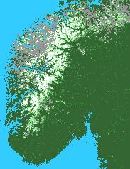
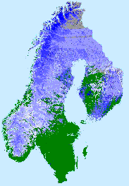
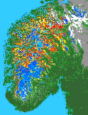
Examples
of the snow products: a) Snow cover area (SCA) (left) with snow-free areas in
green and fractional snow cover in tones between green (0% SCA) and white (100%
SCA); b) Snow temperature for surface (STS) (middle) for temperatures around
0°C in white and lower temperatures in deeper blue (about –10°C
in the north) and c) Snow surface wetness (SSW) (right) with light blue and
yellow showing areas where the snow has just started to melt