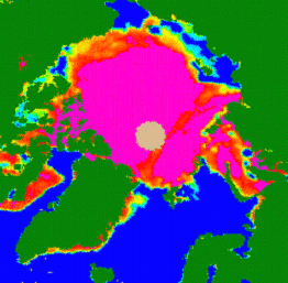
The Aggregated sea
ice concentration (SIC) parameter is the fraction of sea surface cover
by sea ice.
Different sensors and methods can be used to map this fraction but due to
climate in the Arctic (dark in winter, cloudy most of the year) microwave
sensors are used in preference to optical sensors.
In this version of EuroClim SSM/I passive microwave data are used. SSM/I is
a 7-channel multi-frequency, dual-polarity sensor. Channels at 19, 37 and
85 GHz have vertical (V) and horizontal (H) polarities. A single channel at
22 GHz has just the vertical polarity.
Data is taken from NSIDC in the form of daily brightness temperature values for the current SSM/I satellite. The data are normally available two days after acquisition but this has been observed to slacken in summer months as the passive microwave data are then less reliable, resulting in less pressure on speedy delivery.
The geographical area cover is the whole Arctic Ocean.
The SIC algorithm for mapping sea ice cover from SSM/I is derived from the
Comiso Bootstrap approach. This is based on the 19V and 37V channels and has
been shown to work all year with the exception that in summer, melting effects
can reduce the
seen ice concentration and give false results.