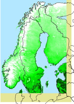
This is a raster product
showing the areas covered with snow in Scandinavia. AVHRR data are used together
with in situ observations from meteorological observing stations. The optical
AVHRR sensor is used to distinguish between clouds, snow and snow free land.
The classification algorithm determines if each pixel over land is cloudy,
snow covered or snow free. The ground observations give the snow cover at
about 500 stations. These are interpolated to each AVHRR pixel using a Digital
Elevation Model. The AVHRR and interpolated observation fields are then compared
and merged into the final product. The snow cover area products are created
by the Norwegian Meteorological Institute.