Glacier
Surface Type
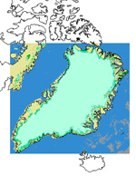
This
is a raster product representing the type of the surface for each pixel from
the Greenland ice-sheets. The glacier surface type belongs to a category between
glacier ice, superimposed ice, wet snow or dry snow. The variable is extracted
from the MODIS images through the Snow mapping algorithm from the MODIS group.
The extraction process is more than 90% accurate. The extraction is set up monthly
by GEUS. The product is a monthly average of all the observations available
for the month. The number of observations is usually close to 20. Indeed the
Terra satellite supporting the MODIS sensor passes over Greenland a number of
times each day. The monthly standard deviation is also stored in the EuroClim
database.
The
resolution of the MODIS sensor is around 250m but the EuroClim product is stored
as 1 km resolution raster images.